- Why should you plan a running route in advance?
- The best apps to track and plan a running route
- How to plan a running route and how to map running distances?
- Plan a running route with Google Maps
- Planning running or cycling routes: other possibilities
- Plan a running route: find new running tracks
- Plan a running route with MapMyRun
- Plan a running route with Komoot
- How to track the running distance?
- Gadgets and wearables: measuring becomes even easier
Especially if you are new to running, it is important to plan your running routes in advance. Otherwise, it is very difficult to know how far you will run. This leads to under- or overestimating oneself and to a lower training success. Without a fixed running distance, runners tend to turn around faster and "give up". But even experienced runners should plan their own running route before the run and measure it during the run. In this case, a suitable time measurement is especially important. This helps you to better understand your own progress and not to lose the fun of running.
- Google Maps
- Strava
- MapMyRun
- onthegomap.com
- Komoot
- Asics Runkeeper
- Adidas Runtastic
- Nike Run Club
When planning a running route, you should try to avoid traffic lights and in general any obstacles that will force you to stop. Frequent pauses will negatively affect the quality of running. It is also worth considering the coating on which you will run, for example, different shoes are needed for asphalt, rubber stadium pavement or soil.
The most popular tool to plan a running route is undisputedly Google Maps. Everyone knows the website or app and everyone has probably used it at some time or another. The good thing is that you can plan a running route using Google Maps or cycling route.
The fastest way is the internal route planner of the app. Here you can enter the start and end point of your running route. In the meantime, especially in densely populated areas, one can rely very well on the available transport options, which give the user the possibility to consider the route as a footpath or cycle path. The walking distance is then displayed as the total length of the route. To individualize the suggested path to do this, set one or more stopovers.
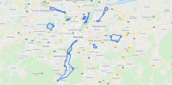
However, since most people don't want to run in the city centre and you often know your way around the mountains or the countryside better than the app, you also have the option to learn how to plan a running route on Google Maps in just a few steps:
Simply open the Google Maps App or website
With a click on the map (on the smartphone tap and hold briefly) a pin appears
On the computer, right-click on the point and select "Measure distance".
On the smartphone, the position of the previously set pin is displayed at the bottom of the screen. Now press on it and also select "Measure distance".
With further mouse clicks onto the map you can set any waypoints on the computer.
Click "Add point" on your smartphone to add a new waypoint.
The total distance between the points is now measured automatically.
Of course Google Maps is not the only way to plan a running or cycling route. There are numerous websites and apps on the internet that are designed for this. Tools such as onthegomap.com work similarly to Google Maps, but are more intuitive to use. All you have to do is go to the website and click on the map to set waypoints.
But sometimes you just want to find a new and suitable route quickly without having to plan it yourself. Applications such as Strava, MapMyRun or Komoot can help here.
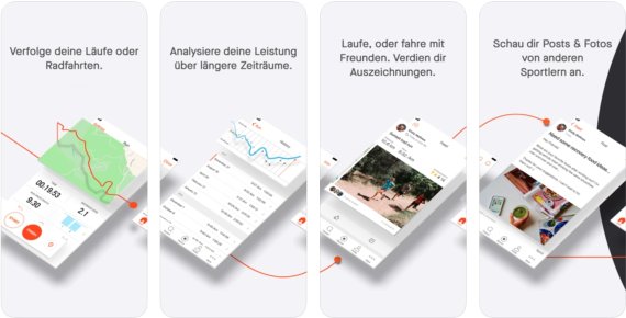
Strava is one of the most popular apps about running and cycling. Strava's mobile app and website were designed by athletes for athletes and connect millions of runners and cyclists. Strava enables the tracking and planning of running and cycling activities. With the premium version of the app, even routes of other athletes can be used. You enter how far you want to run and whether you want to avoid climbs and hills, and the app now suggests numerous nearby routes based on where other runners and cyclists have run or ridden. Of course Strava also offers the possibility to plan routes yourself.
The running app MapMyRun also offers runners the possibility to plan their own routes or search for popular running routes nearby. The app also allows users to save favorite routes and access them in the app if they get lost during the run.
Komoot is a particularly popular app among cyclists, which allows you to plan cycling routes. The advantage with Komoot is the direct link to numerous cycling computers such as Garmin Edge or Wahoo Elemnt.
Komoot also has the advantage of being able to access popular running and cycling routes of other users.
By the way, all of the above mentioned applications of course also offer the possibility to measure the distance covered, running or driving speed and many other parameters during the activity. This is of course especially helpful to keep track of your own progress.
But of course there are also numerous apps for measuring activities, each with different advantages and disadvantages. We have already presented a large part of them here in this article and in our text on fitness apps. Nevertheless, here is a short list of our favourites:
The functions of the apps mentioned are essentially the same. Via GPS, the apps measure the distance travelled, the time and many other parameters, such as metres of altitude covered, calories burned and much more. The decision for an app is often made spontaneously or based on the personally perceived user experience. However, if you have special needs when running or cycling, for example linking the app to various wearables, you should find out individually which application offers this.
For tracking your running distance, it is best to use special applications that adapt to you. They record the data of each workout, track the pace, pulse rate, elevation, calories, step rate (cadence) and many more metrics. They also create a training plan.
As in all areas of sport, more and more wearables are of course coming onto the market for measuring running distance and cycling. The cycling computers just mentioned today usually have connection possibilities with the smartphone to transfer routes and other data between the two devices. It is the same with running watches.
For users, who want to measure a distance for running, the most important is to think about which functions are really needed and which functions should be used. For example, is sleep tracking a must for a running clock? Is a wrist-worn heart rate monitor at the top of the wish list? Do you only want to use the watch for running, or should the functions be available for other sports? Which apps should the wearables work with? If you define exactly what the gadget to measure distance while running should do for the wearer, it will be much easier to get an overview in the almost unmanageable market.
At the same time, for experienced runners and cyclists who always want the latest gadgets, it is worth keeping an eye on the wearables market. In addition to computers, running watches, smart watches and much more, smart running shoes are now also available. Under Armour offers for example the HOVR, a shoe that can be directly connected to the app MapMyRun (ISPO.com reported).
- Awards
- Mountain sports
- Bike
- Fitness
- Health
- ISPO Munich
- Running
- Brands
- Sustainability
- Olympia
- OutDoor
- Promotion
- Sports Business
- Textrends
- Triathlon
- Water sports
- Winter sports
- eSports
- SportsTech
- OutDoor by ISPO
- Heroes
- Transformation
- Sport Fashion
- Urban Culture
- Challenges of a CEO
- Trade fairs
- Sports
- Find the Balance
- Product reviews
- Newsletter Exclusive Area
- Magazine
